Infrastructure & Transportation
Show by :

DJI Terra Post Processing Software
DJI Terra is a drone data processing software (photogrammetry & LiDAR) developed by DJI to convert aerial data into 2D maps, 3D models, and geospatial analysis quickly and accurately...
More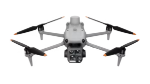
DJI Matrice 4 Thermal
A compact flagship drone equipped with 6 lenses and AI recognition that can detect humans, ships, vehicles, and other objects (customizable) to support various security, inspection, and search & rescue operations, both day and night...
More