April 2026 – In the coal mining industry, the risk of self-heating in stockpiles is not just a technical issue, but also a safety and operational sustainability issue. Coal stored in large volumes can undergo natural oxidation. If not properly monitored, this process has the potential to slowly increase temperatures beyond safe limits and trigger a fire risk, especially prior to distribution by barge.
The permissible temperature threshold in many operational procedures is below 50°C. Exceeding this limit not only increases the potential for incidents but also risks logistical disruptions, quality claims, and even financial losses. Therefore, a technology-based monitoring approach is becoming increasingly relevant.
On April 1–4, 2026, an on-site Proof of Concept (POC) was conducted using a thermal drone system to comprehensively map and analyze the surface temperature of a coal stockpile. The platform used was the DJI Matrice 4T, supported by data processing via DJI Thermal and DJI Terra.
Despite rain on the first day of the mission, the data acquisition process still proceeded smoothly. Weather conditions pose a challenge to drone operations, particularly in maintaining flight stability and thermal data quality. However, with proper mission planning—from altitude settings, image overlap, to sensor calibration—data can still be consistently acquired and further analyzed.
The thermal imaging approach allows for visual and quantitative identification of temperature variations. Unlike manual measurements using a thermogun, which are point-by-point, thermal drones can map large areas in a relatively short time, producing a more comprehensive picture of heat distribution. This is particularly important in stockpiles, as hotspots are often invisible from the surface and unevenly distributed.
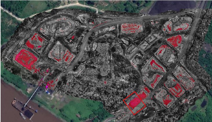
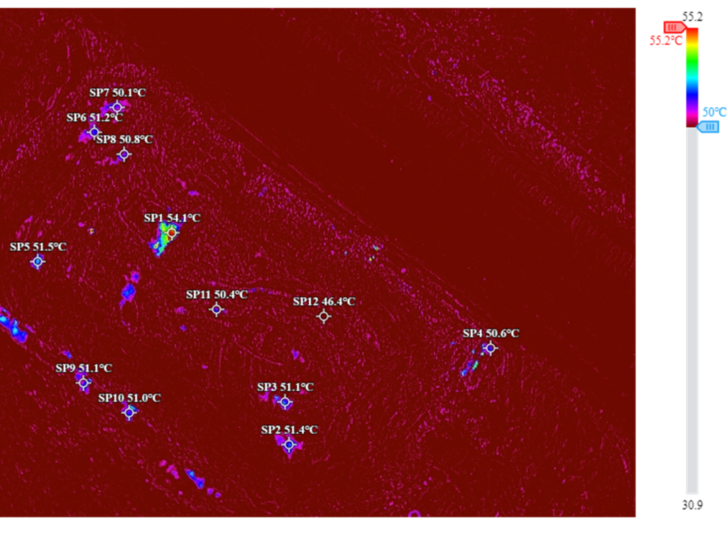
Initial mapping results identified several points and areas with temperatures ranging between 40°C and 60°C. Areas approaching and exceeding 50°C were of particular concern as they were above the recommended safety limits prior to distribution. The thermal data processed in DJI Terra was then analyzed to determine the precise locations of hotspots, including an estimate of the extent of the impacted area.
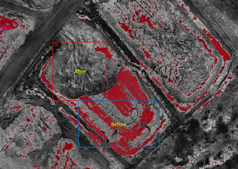
The key insight from this POC wasn't just identifying hot spots, but also demonstrating how spatial data can support rapid and targeted preventive action. Based on these findings, the operational team conducted treatment using a special fluid to lower the temperature in the identified areas.
Some time after the treatment, data collection was repeated using the same procedure to ensure consistency of readings. The results showed a significant decrease in temperature, with the entire area returning to the safe range of below 50°C. This data-driven validation demonstrates that the thermal monitoring approach serves not only as a detection tool but also as an instrument for evaluating the effectiveness of corrective actions.
From a risk management perspective, this approach represents a shift from a reactive to a preventative system. Rather than waiting for visual indications such as smoke or a burning odor, a thermal monitoring system enables early identification before conditions escalate into incidents. In the context of barge distribution, this preventative measure is crucial because the risk of fire on board can have a far greater impact, both on safety and operational aspects.
Furthermore, the use of thermal drones offers significant efficiency. Large stockpile areas with uneven contours often make manual inspections difficult. With drones, the monitoring process can be carried out faster, safer, and without the need for personnel to be stationed in high-risk areas. The resulting data is also well-documented and can be used as a historical archive for analyzing temperature trends over time.
This POC demonstrates that the integration of thermal hardware and spatial processing software is not just a technological solution, but part of a more robust risk management strategy in the mining industry. When data informs decision-making, actions are more precise, measurable, and accountable.
In the long term, thermal drone-based stockpile temperature monitoring has the potential to become a new standard in coal mining operations. With scheduled monitoring frequency and systematic documentation, companies can build stronger early warning systems, maintain material quality, and ensure safe distribution.
Ultimately, technology is not just a tool, but an enabler for safer, more efficient, and data-driven operations. And in the context of coal stockpile management, the ability to detect and address hotspots before they exceed critical limits is a real investment in operational safety and sustainability.
Author Kholis Muhsin Lubis
January 2026 — With the increasing need for efficiency and accuracy in mine management, Continuously Operating Reference Station (CORS) technology has become a vital infrastructure. Entering the first quarter of 2026, CORS implementation in the mining sector is now required to refer to SNI 7964:2022, the national standard that regulates the technical specifications for the development of this infrastructure to ensure high precision and data sustainability.
The construction of CORS in mining concession areas is not just about installing GNSS antennas, but rather a precise geodetic process to support survey activities, slope monitoring (PIT), and autonomous heavy equipment navigation.
Implementation Based on SNI 7964:2022Based on the latest regulations, the construction of CORS in the mining segment must meet several main technical criteria:
Monument Stability: Considering the dynamics of the soil in the mining area, the monument must be built on stable rock (bedrock) or with reinforced concrete construction that goes deep into the ground to avoid local displacement effects.
Device Specifications: The use of multi-frequency and multi-constellation GNSS receivers (GPS, GLONASS, Galileo, BeiDou) has become a mandatory standard to ensure signal availability in mining areas which often have multipath challenges.
Data Connectivity: Data transmission must be stable using the NTRIP protocol to support Real-Time Kinematic (RTK) correction for the survey team in the field.
Integration with the Indonesian Geospatial Reference System (SRGI)
One crucial aspect of this development is integration with the SRGI. According to the Geospatial Information Agency (BPGI) Regulation, every coordinate generated within Indonesian jurisdiction must refer to a single reference.
By integrating the mine's CORS into the SRGI network, the company ensures that all mapping data—from both LiDAR drones and terrestrial surveys—is spatially consistent with national maps. This prevents overlapping concessions and simplifies reporting of Work Plans and Budgets (RKAB) to relevant ministries.
The Strategic Role of the Geospatial Information Agency (BIG)
To ensure that the infrastructure being built meets legal and technical standards, the construction process involves two crucial stages that are directly supervised by the Geospatial Information Agency (BIG):
Development Supervision: This is done from the site selection stage to ensure that the location is free from electromagnetic interference and has minimal obstruction.
Commissioning ActivitiesThis is the final functional test before the station is officially operational. A team of experts will validate data quality (SN Ratio, Multipath, Data Gaps) and ensure the station's coordinates are correctly tied to the National Geodetic Control Network.
The Importance of Standardization: Without commissioning and supervision from BIG, data from the CORS station cannot be accredited as official data in the national geospatial information system, which risks the legal validity of the mining mapping results.
Manfaat bagi Operasional Pertambangan
Di awal tahun 2026 ini, integrasi teknologi Drone LiDAR dengan koreksi dari stasiun CORS yang terstandarisasi memberikan lompatan produktivitas yang signifikan:
Precision Mapping: Horizontal and vertical position accuracy reaches sub-decimeter level (below 10 cm).
Monitoring Real-Time: Early detection of ground movement or potential landslides on mine walls continuously 24/7.
Cost Efficiency: Reduces the need for time-consuming and high-risk ground control point (GCP) installation in the field.
The construction of a CORS in accordance with SNI 7964:2022 is no longer just a technical choice, but a strategic investment for mining companies to achieve good mining governance (Good Mining Practice) and national integration.
Author Kholis Muhsin Lubis
Ketika Operator Excavator Masih Mengandalkan Patok Kayu, Industri Tambang Sudah Kehilangan Banyak Uang
Juli 26 – Setiap hari, ribuan alat berat bekerja di area tambang Indonesia. Excavator menggali overburden, dozer membentuk disposal, motor grader meratakan haul road, dan compactor memastikan setiap layer memenuhi spesifikasi desain.
Namun di banyak lokasi, proses tersebut masih dilakukan dengan cara yang hampir sama seperti puluhan tahun lalu.
Surveyor memasang patok. Operator mengikuti patok tersebut. Setelah pekerjaan selesai, surveyor kembali melakukan pengecekan. Jika elevasi belum sesuai, alat berat harus bekerja kembali. Siklus ini terlihat sederhana, tetapi menghasilkan biaya tersembunyi yang sangat besar:
- Waktu alat berat terbuang.
- Konsumsi solar meningkat.
- Rework berulang.
- Material terbuang.
- Produksi tertunda.
- Risiko keselamatan meningkat karena surveyor bekerja di dekat alat berat.
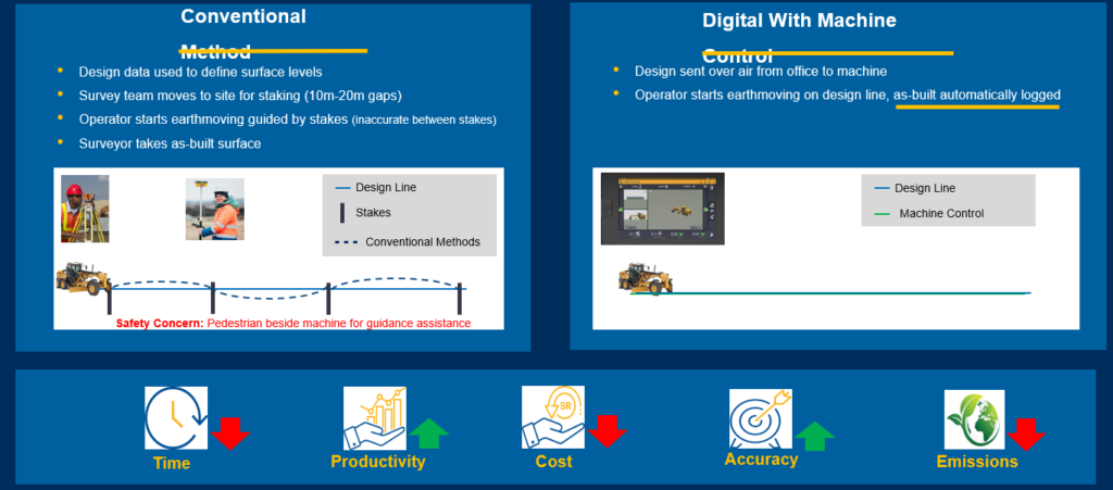
Di era digital, pendekatan seperti ini mulai ditinggalkan. Industri pertambangan global bergerak menuju Machine Control, sebuah teknologi yang menghubungkan desain tambang langsung ke alat berat sehingga operator dapat bekerja berdasarkan model digital tanpa bergantung pada staking manual. Konsep digital construction ini terbukti meningkatkan pengambilan keputusan, produktivitas, akurasi, serta mengurangi kebutuhan rework secara signifikan.
Apa Itu Machine Control?
Machine Control adalah sistem yang mengintegrasikan:
- GNSS presisi tinggi
- Sensor kemiringan (IMU)
- Sistem hidrolik
- Komputer di kabin operator
- Model desain 3D
- Software manajemen proyek
Semua komponen tersebut bekerja secara real-time untuk menunjukkan posisi bucket, blade, atau attachment terhadap desain pekerjaan.
Operator tidak lagi bekerja berdasarkan tebakan atau patok.
Operator bekerja langsung pada model digital.
Pada beberapa alat berat, sistem bahkan mampu mengontrol blade atau attachment secara otomatis sehingga elevasi desain dapat dicapai dengan presisi tinggi.
Mengapa Industri Tambang Indonesia Membutuhkan Machine Control?
Tekanan terhadap industri pertambangan terus meningkat.
Perusahaan dituntut untuk:
- meningkatkan produksi,
- menekan biaya operasional,
- memperbaiki aspek keselamatan,
- mengurangi emisi karbon,
- serta mempercepat siklus kerja.
Ironisnya, sebagian besar efisiensi tersebut justru dapat diperoleh dari proses earthmoving.
Pekerjaan seperti:
- pembangunan haul road,
- pembentukan disposal,
- pembangunan settling pond,
- penyiapan stockpile,
- hingga konstruksi infrastruktur tambang,
masih banyak yang bergantung pada metode manual. Padahal pekerjaan tersebut merupakan aktivitas yang dilakukan setiap hari.
Masalah yang Sering Terjadi di Lapangan
Beberapa tantangan yang hampir selalu ditemui di operasi tambang antara lain:
1. Over Cut dan Under Cut
Kesalahan elevasi menyebabkan material yang seharusnya tidak tergali justru ikut terambil.
Sebaliknya, material yang seharusnya dipotong masih tersisa.
Akibatnya:
- volume pekerjaan bertambah,
- konsumsi bahan bakar meningkat,
- produktivitas turun.
2. Rework
Rework merupakan salah satu pemborosan terbesar dalam pekerjaan earthmoving. Alat berat harus kembali bekerja hanya karena elevasi belum memenuhi desain.
3. Survey Berulang
Surveyor harus terus melakukan staking.
- Patok hilang.
- Patok tertabrak.
- Patok berpindah.
Semua harus diulang kembali.
4. Risiko Keselamatan
Pada metode konvensional, surveyor sering bekerja sangat dekat dengan alat berat. Machine Control mengurangi kebutuhan staking di lapangan sehingga meningkatkan keselamatan personel.
Solusi: Digital Earthmoving dengan Machine Control
Dalam sistem Machine Control, seluruh desain dikirim secara digital dari kantor ke alat berat.
- Operator melihat model 3D langsung dari monitor di dalam kabin.
- Tidak diperlukan lagi staking yang intensif.
- Perubahan desain pun dapat dikirim dalam hitungan menit tanpa harus menghentikan pekerjaan.
Alur kerja digital ini menggantikan metode konvensional yang bergantung pada patok lapangan dan pengukuran berulang.
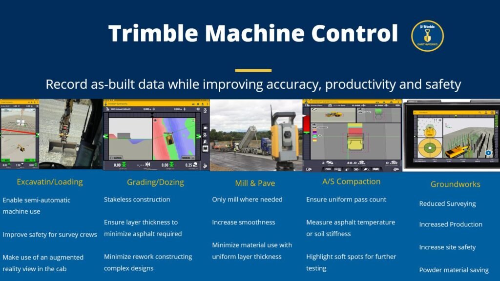
Teknologi yang Digunakan
Implementasi Machine Control biasanya terdiri dari:
GNSS Presisi Tinggi
Menentukan posisi alat berat secara real-time.
Sensor Sudut
Mengukur posisi blade atau bucket.
IMU
Menghitung orientasi alat.
Software Machine Control
Menampilkan desain 3D kepada operator.
Cloud Platform
Sinkronisasi desain, progress, dan data produksi antara kantor dan lapangan.
Trimble juga menyediakan ekosistem Trimble Business Center, WorksManager, dan WorksOS untuk menghubungkan workflow mulai dari pengolahan data, distribusi model ke alat berat, hingga monitoring produktivitas dan as-built secara real-time.
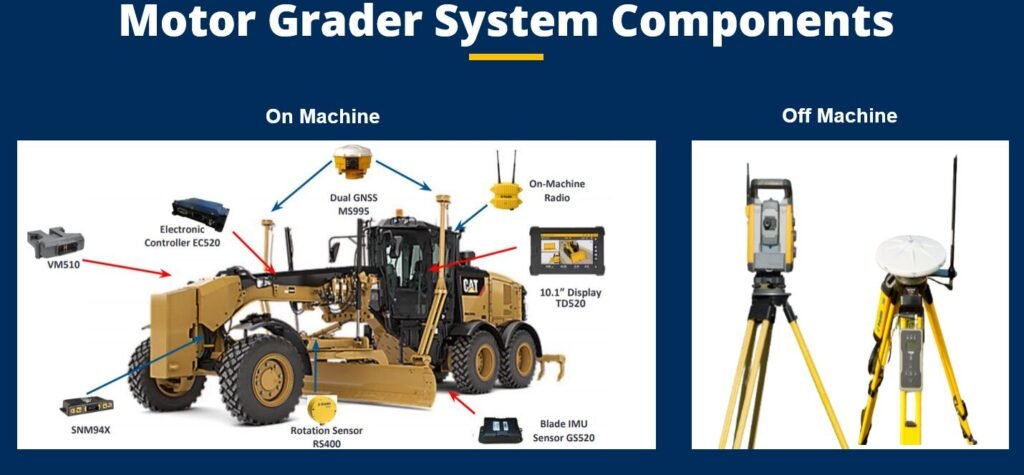
Studi Kasus: NEOM, Arab Saudi
Salah satu implementasi paling menarik berasal dari proyek NEOM di Arab Saudi.
Dalam proyek tersebut digunakan:
- Motor Grader
- Dozer
- Soil Compactor
yang telah dilengkapi Machine Control.
Hasilnya sangat mencolok.
Pada pekerjaan TOE Layer sepanjang 1 km:
Dengan Machine Control:
- selesai dalam 25,5 jam,
- 99,8% area langsung sesuai desain (on grade).
Metode konvensional:
- membutuhkan 71 jam,
- tingkat kesesuaian desain kurang dari 71%.
Dampak yang Dihasilkan
Hasil Proof of Concept menunjukkan peningkatan yang konsisten:
- waktu kerja turun 52–68%,
- produktivitas meningkat 108–143%,
- biaya operasional turun 46–65%,
- akurasi meningkat hingga 72%,
- emisi berkurang hingga 77% tergantung jenis alat berat.
Hasil serupa juga terlihat pada proyek SG Layer, dengan peningkatan produktivitas dan pengurangan biaya yang signifikan.
Bagaimana Potensinya di Indonesia?
Indonesia memiliki karakteristik yang sangat cocok untuk penerapan Machine Control.
Terutama pada:
- Tambang batubara.
- Tambang nikel.
- Tambang emas.
- Tambang bauksit.
- Quarry.
- Proyek smelter.
- Jalan tambang.
Aktivitas grading dan earthmoving berlangsung hampir setiap hari. Sedikit peningkatan efisiensi saja dapat menghasilkan penghematan miliaran rupiah setiap tahun.
Kombinasi Machine Control dan Teknologi Geospasial
Nilai terbesar muncul ketika Machine Control diintegrasikan dengan teknologi geospasial lainnya.
Contohnya:
GNSS Trimble
Sebagai referensi posisi presisi tinggi.
Drone DJI Enterprise
Memperbarui topografi pit dan stockpile secara cepat.
Trimble Business Center
Mengolah desain, volume, serta data as-built menjadi model yang siap dikirim ke alat berat.
Laser Scanner
Memvalidasi hasil pekerjaan dan mendukung dokumentasi digital.
Ekosistem seperti ini memungkinkan seluruh siklus data—dari survei, desain, eksekusi, hingga verifikasi—berjalan lebih cepat dan konsisten.
Berapa Nilai Investasinya?
Besarnya investasi bergantung pada jenis alat dan konfigurasi sistem.
Sebagai gambaran:
- Sistem Machine Control per alat berat: Rp500 juta – Rp1,8 miliar.
- GNSS Survey Grade: Rp100 juta – Rp700 juta.
- Software Trimble Business Center: mulai puluhan juta rupiah, tergantung modul.
- Platform sinkronisasi data dan manajemen proyek: disesuaikan dengan skala implementasi.
Dibandingkan biaya operasional alat berat yang dapat mencapai miliaran rupiah per tahun, investasi ini sering kali memiliki periode pengembalian yang relatif singkat.
Mengapa Memilih Mitra yang Tepat?
Keberhasilan implementasi Machine Control tidak hanya bergantung pada perangkat keras.
Yang jauh lebih penting adalah:
- analisis kebutuhan operasional,
- integrasi software,
- pelatihan operator,
- workflow data,
- serta dukungan teknis jangka panjang.
Sebagai distributor resmi solusi geospasial dan konstruksi digital, GPS Lands Indosolutions memiliki pengalaman dalam menghadirkan solusi Trimble untuk sektor pertambangan, konstruksi, energi, dan infrastruktur.
Portofolio solusi yang dapat diintegrasikan meliputi:
- GNSS Trimble (DA2 Catalyst, R580, R780, R980),
- Total Station dan sistem monitoring,
- Trimble Business Center,
- Drone DJI Enterprise,
- Laser Scanner,
- konsultasi workflow digital,
- pelatihan operator dan implementasi.
Pendekatan ini membantu perusahaan tidak hanya membeli teknologi, tetapi membangun sistem kerja digital yang menghasilkan efisiensi nyata.
Kesimpulan
Machine Control bukan lagi teknologi masa depan—ia telah menjadi standar baru bagi perusahaan yang ingin meningkatkan produktivitas, akurasi, dan keselamatan kerja. Pengalaman proyek-proyek internasional menunjukkan bahwa digitalisasi earthmoving mampu memangkas waktu kerja, mengurangi rework, menekan biaya, dan meningkatkan kualitas hasil secara signifikan.
Bagi industri pertambangan Indonesia, peluangnya sangat besar. Dengan menggabungkan Machine Control, GNSS, drone, laser scanner, dan software manajemen data dalam satu ekosistem yang terintegrasi, perusahaan dapat beralih dari proses yang reaktif menjadi operasi yang berbasis data dan keputusan real-time.
Pada akhirnya, transformasi digital bukan hanya tentang membeli teknologi baru. Transformasi digital adalah tentang membangun cara kerja yang lebih cerdas, lebih aman, dan lebih produktif—agar setiap meter kubik material, setiap liter bahan bakar, dan setiap jam kerja benar-benar memberikan nilai maksimal bagi perusahaan..
Author Kholis Muhsin Lubis
Industri Tambang Sedang Berubah, Apakah Sistem Survey Anda Sudah Mengikutinya?
Juli 26 – Dalam beberapa tahun terakhir, industri pertambangan Indonesia mengalami transformasi yang sangat cepat. Jika dahulu survey hanya dianggap sebagai fungsi pendukung untuk menghasilkan peta dan menghitung volume, kini data survey menjadi fondasi utama dalam pengambilan keputusan operasional.
Mine planning membutuhkan data yang lebih cepat. Tim produksi membutuhkan informasi yang lebih akurat. Geoteknik membutuhkan monitoring yang lebih sering. Manajemen membutuhkan dashboard yang dapat diakses kapan saja tanpa harus menunggu laporan mingguan.
Di sisi lain, target produksi terus meningkat sementara tekanan terhadap efisiensi biaya semakin besar.
Kondisi ini memunculkan satu pertanyaan penting:
Bagaimana wajah survey tambang Indonesia pada tahun 2027?
Jawabannya bukan sekadar drone yang lebih canggih atau GNSS yang lebih akurat. Perubahan terbesar justru terjadi pada cara data dikumpulkan, diolah, diintegrasikan, dan digunakan untuk mengambil keputusan secara real-time.
Mengapa Digital Survey Menjadi Prioritas?
Sebagian besar tambang modern saat ini menghasilkan data dalam jumlah yang sangat besar setiap hari.
Mulai dari:
- Topografi pit.
- Perhitungan volume stockpile.
- Monitoring disposal.
- Survey jalan tambang.
- Monitoring lereng.
- Progress hauling.
- Data geoteknik.
- Dokumentasi aset.
Masalahnya bukan lagi kekurangan data.
Masalah terbesar justru adalah bagaimana mengubah data tersebut menjadi informasi yang dapat digunakan dengan cepat.
Banyak perusahaan masih menghadapi kondisi di mana:
- Data drone membutuhkan beberapa hari untuk diproses.
- Data GNSS tersimpan di berbagai komputer berbeda.
- Hasil survey tidak terhubung dengan software mine planning.
- Informasi lapangan terlambat sampai ke pengambil keputusan.
Akibatnya, keputusan operasional sering dibuat berdasarkan data yang sudah tidak lagi mencerminkan kondisi aktual.
Tahap 1: Digitalisasi Akuisisi Data (2025–2026)
Sebagian besar perusahaan tambang Indonesia saat ini sedang berada pada fase digitalisasi akuisisi data.
Pada tahap ini mulai terjadi pergeseran dari metode konvensional menuju teknologi digital seperti:
GNSS Modern
Penggunaan receiver multi-konstelasi dengan kemampuan RTK dan RTX semakin meningkat.
Teknologi seperti:
- Trimble DA2 Catalyst
- Trimble R580
- Trimble R780
- Trimble R980
memungkinkan pengukuran tetap berjalan meskipun berada di lokasi yang jauh dari jaringan CORS.
Bagi tambang yang beroperasi di Kalimantan, Sulawesi, Maluku, hingga Papua, kemampuan ini menjadi sangat penting.
Drone Mapping
Drone tidak lagi hanya digunakan untuk dokumentasi udara.
Saat ini drone telah menjadi alat utama untuk:
- Survey pit.
- Perhitungan volume.
- Monitoring disposal.
- Progress pekerjaan.
Perusahaan yang sebelumnya membutuhkan beberapa hari untuk survey area luas kini dapat memperoleh data dalam hitungan jam.
Tahap 2: Integrasi Data Geospasial (2026–2027)
Setelah proses akuisisi semakin cepat, tantangan berikutnya adalah integrasi. Di sinilah banyak perusahaan mulai menyadari bahwa memiliki alat canggih saja tidak cukup. Data harus mampu mengalir secara otomatis ke dalam sistem operasional perusahaan.
Roadmap menuju 2027 menunjukkan bahwa perusahaan tambang akan semakin mengandalkan integrasi antara:
- GNSS.
- Drone.
- Laser Scanner.
- Monitoring System.
- Software Mine Planning.
- Dashboard Manajemen.
Tujuannya adalah menciptakan satu sumber data yang konsisten untuk seluruh departemen.
Monitoring Lereng Akan Menjadi Standar Baru
Salah satu perubahan terbesar yang diprediksi terjadi sebelum 2027 adalah meningkatnya kebutuhan monitoring geoteknik berbasis data.
Inspeksi visual masih penting.
Namun tidak lagi cukup.
Perusahaan tambang mulai beralih menuju kombinasi teknologi:
- Monitoring GNSS.
- Robotic Total Station.
- Terrestrial Laser Scanner.
- Radar monitoring.
- Drone photogrammetry.
- Drone LiDAR.
Pendekatan ini memungkinkan pergerakan lereng beberapa milimeter sekalipun dapat terdeteksi lebih awal. Bagi perusahaan yang mengelola pit dengan kedalaman ratusan meter, kemampuan ini bukan hanya soal produktivitas tetapi juga keselamatan.
Digital Twin Akan Menjadi Aset Strategis
Istilah digital twin mulai sering muncul dalam berbagai konferensi pertambangan global. Pada dasarnya, digital twin adalah representasi digital dari kondisi aktual di lapangan.
Teknologi ini dibangun menggunakan:
- Drone.
- Laser Scanner.
- GNSS.
- IoT Sensor.
- Data Operasional.
Dengan digital twin, perusahaan dapat:
- Melihat kondisi tambang secara virtual.
- Melakukan simulasi perubahan desain.
- Mengevaluasi risiko operasional.
- Mengoptimalkan produksi.
Banyak perusahaan tambang global telah menjadikan digital twin sebagai bagian dari strategi transformasi digital mereka.
Indonesia diperkirakan akan mengikuti tren yang sama dalam beberapa tahun ke depan.
AI dan Otomasi Akan Mengubah Cara Survey Bekerja
Pada tahun 2027, peran surveyor tidak lagi hanya mengumpulkan data.
Fokus akan bergeser menjadi:
- Validasi data.
- Analisis.
- Pengambilan keputusan.
Berbagai proses yang saat ini masih dilakukan secara manual mulai diotomatisasi.
Contohnya:
- Deteksi perubahan topografi otomatis.
- Perhitungan volume otomatis.
- Monitoring progres otomatis.
- Analisis risiko lereng berbasis AI.
Surveyor masa depan akan lebih banyak bekerja sebagai analis geospasial dibanding sekadar operator alat.
Tantangan Terbesar Tambang Indonesia
Meskipun teknologinya tersedia, implementasi digital survey tidak selalu mudah. Beberapa tantangan yang masih sering ditemui:
- Kurangnya integrasi antar sistem.
- Keterbatasan SDM.
- Infrastruktur komunikasi di area remote.
- Standarisasi data yang belum seragam.
- Resistensi terhadap perubahan workflow.
Karena itu roadmap digital survey harus dibangun secara bertahap sesuai kebutuhan operasional masing-masing perusahaan.
Berapa Nilai Investasi Transformasi Digital Survey?
Banyak perusahaan menganggap transformasi digital sebagai biaya tambahan.
Padahal kenyataannya lebih tepat disebut investasi operasional.
Sebagai gambaran:
GNSS Survey Grade
Rp100 juta – Rp700 juta
Drone Mapping
Rp80 juta – Rp600 juta
Drone LiDAR
Rp800 juta – Rp3 miliar+
Terrestrial Laser Scanner
Rp500 juta – Rp4 miliar+
Monitoring System
Rp500 juta – Rp10 miliar+
Software dan Data Management
Rp50 juta – Rp2 miliar+
Nilai tersebut mungkin terlihat besar.
Namun jika dibandingkan dengan biaya rework, kehilangan produksi, atau potensi insiden geoteknik, investasi ini relatif kecil.
Studi Nyata di Indonesia
Dalam beberapa tahun terakhir, banyak tambang batubara dan nikel di Indonesia mulai mengadopsi:
- Drone untuk stockpile dan pit survey.
- GNSS premium untuk kontrol survey.
- Monitoring lereng berbasis sensor.
- Laser scanning untuk dokumentasi aset.
Hasil yang paling sering dilaporkan adalah:
- Pengurangan waktu survey hingga 80%.
- Peningkatan frekuensi monitoring.
- Pengurangan risiko keselamatan.
- Data yang lebih cepat tersedia untuk mine planning.
- Pengambilan keputusan yang lebih responsif.
Ini menunjukkan bahwa transformasi digital bukan lagi konsep masa depan. Transformasi tersebut sedang berlangsung saat ini.
Peran Mitra Teknologi Menjadi Semakin Penting
Keberhasilan digital survey tidak hanya ditentukan oleh perangkat yang digunakan. Lebih penting lagi adalah kemampuan mengintegrasikan seluruh workflow menjadi satu ekosistem yang efisien.
Di sinilah peran perusahaan solusi geospasial menjadi krusial.
Sebagai salah satu perusahaan yang telah melayani industri survey dan pemetaan selama hampir dua dekade, GPS Lands Indosolutions menghadirkan berbagai solusi yang mendukung roadmap digital tambang modern, mulai dari:
- GNSS Survey Grade Trimble.
- Total Station dan Monitoring System.
- Terrestrial Laser Scanner.
- Drone Mapping dan Drone LiDAR DJI Enterprise.
- Trimble Business Center.
- Konsultasi implementasi workflow geospasial.
Pendekatan yang paling efektif bukan sekadar membeli alat, tetapi membangun sistem yang mampu menghasilkan data yang konsisten dan dapat digunakan oleh seluruh departemen.
Kesimpulan
Roadmap Digital Survey Tambang Indonesia 2027 bukan hanya tentang penggunaan drone, GNSS, atau laser scanner yang lebih canggih. Transformasi yang sesungguhnya terjadi pada bagaimana data dikumpulkan, diintegrasikan, dianalisis, dan dimanfaatkan untuk mendukung keputusan operasional secara real-time.
Perusahaan tambang yang mulai membangun fondasi digital sejak sekarang akan memiliki keunggulan yang signifikan dalam hal efisiensi, keselamatan, produktivitas, dan pengelolaan risiko. Sebaliknya, perusahaan yang masih mengandalkan workflow manual berisiko tertinggal di tengah tuntutan industri yang semakin kompetitif.
Pada akhirnya, masa depan survey tambang bukan lagi sekadar menghasilkan peta. Masa depan survey adalah menyediakan informasi yang tepat, pada waktu yang tepat, untuk membantu perusahaan membuat keputusan yang lebih baik setiap hari. Dan itulah inti dari transformasi digital yang sedang berlangsung di industri pertambangan Indonesia.bagi organisasi Anda.
Author Kholis Muhsin Lubis
Membeli Laser Scanner Bukan Sekadar Memilih Jarak Terjauh
Juli 26 – Pasar laser scanner saat ini berkembang sangat pesat. Hampir setiap tahun muncul perangkat baru dengan klaim lebih cepat, lebih ringan, lebih akurat, dan mampu menghasilkan jutaan titik per detik. Bagi perusahaan yang baru akan berinvestasi, kondisi ini justru sering membingungkan.
Tidak sedikit perusahaan yang akhirnya membeli laser scanner berdasarkan spesifikasi tertinggi atau harga termurah, namun beberapa bulan kemudian menyadari bahwa perangkat tersebut tidak sesuai dengan kebutuhan operasional mereka.
Padahal investasi laser scanner bukanlah keputusan kecil. Nilainya bisa mencapai ratusan juta hingga miliaran rupiah. Kesalahan memilih alat dapat berdampak pada produktivitas tim, kualitas data, bahkan keberhasilan sebuah proyek.
Karena itu, pertanyaan pertama yang perlu dijawab bukanlah:
“Laser scanner mana yang paling canggih?”
Melainkan:
“Masalah apa yang ingin diselesaikan oleh laser scanner tersebut?”
Memahami Kebutuhan Sebelum Melihat Spesifikasi
Banyak perusahaan langsung membandingkan:
- Jangkauan scanner.
- Kecepatan scan.
- Jumlah titik per detik.
- Akurasi.
Padahal kebutuhan setiap industri sangat berbeda.
Misalnya:
Perusahaan tambang mungkin membutuhkan scanner untuk:
- Monitoring highwall.
- Perhitungan volume stockpile.
- Digital twin pit.
- Monitoring deformasi.
Sementara perusahaan industri lebih fokus pada:
- As-built plant.
- Reverse engineering.
- Digital twin fasilitas produksi.
- Clash detection.
Sedangkan konsultan konstruksi biasanya memerlukan:
- BIM.
- Verifikasi progres proyek.
- Dokumentasi bangunan.
- Quality control konstruksi.
Karena itu pemilihan scanner harus dimulai dari kebutuhan bisnis, bukan brosur produk.
Pertanyaan Pertama: Seberapa Jauh Objek yang Akan Dipindai?
Jarak kerja merupakan faktor yang sangat menentukan.
Jarak Pendek (0–100 meter)
Cocok untuk:
- Interior bangunan.
- Mechanical room.
- BIM.
- Pabrik.
- Utility mapping.
Jarak Menengah (100–500 meter)
Cocok untuk:
- Stockpile.
- Infrastruktur.
- Jalan.
- Jembatan.
Jarak Jauh (500 meter – 2 km+)
Cocok untuk:
- Tambang terbuka.
- Lereng tambang.
- Bendungan.
- Monitoring deformasi.
Kesalahan yang sering terjadi adalah membeli scanner jarak pendek untuk pekerjaan tambang yang membutuhkan jangkauan ratusan meter. Akibatnya jumlah setup menjadi sangat banyak dan produktivitas turun drastis.
Jangan Terjebak pada Jumlah Titik per Detik
Produsen sering menonjolkan angka seperti:
- 500.000 titik/detik.
- 1 juta titik/detik.
- 2 juta titik/detik.
Angka tersebut memang menarik, tetapi bukan satu-satunya indikator kualitas. Yang lebih penting adalah:
- Akurasi titik.
- Noise level.
- Konsistensi data.
- Kualitas registrasi.
- Kemampuan bekerja pada permukaan reflektif.
Dalam banyak proyek industri, point cloud yang bersih lebih berharga dibanding point cloud yang sangat padat tetapi penuh noise.
Akurasi yang Dibutuhkan Tidak Selalu Sama
Salah satu kesalahan paling mahal adalah membeli scanner dengan akurasi yang tidak sesuai kebutuhan.
Sebagai contoh:
Digital Twin Industri
Biasanya membutuhkan akurasi:
±2–5 mm
BIM dan Konstruksi
Biasanya membutuhkan:
±3–10 mm
Monitoring Struktur
Biasanya membutuhkan:
±1–5 mm
Topografi dan Stockpile
Biasanya cukup:
±1–3 cm
Jika pekerjaan utama hanya volume stockpile, membeli scanner dengan akurasi sub-milimeter mungkin tidak memberikan nilai tambah yang signifikan.
Studi Kasus: Digital Twin Smelter di Indonesia
Dalam beberapa tahun terakhir, banyak fasilitas smelter nikel di Sulawesi dan Maluku mulai membangun digital twin untuk mendukung operasi dan maintenance. Salah satu tantangan terbesar adalah dokumentasi kondisi aktual fasilitas yang telah mengalami banyak perubahan sejak konstruksi awal.
Menggunakan metode survey konvensional, proses pengukuran dapat memakan waktu berminggu-minggu. Dengan terrestrial laser scanner, seluruh area fasilitas dapat didokumentasikan dalam hitungan hari.
Data point cloud kemudian digunakan untuk:
- Pemodelan 3D.
- Clash detection.
- Perencanaan maintenance.
- Simulasi ekspansi fasilitas.
Dalam proyek seperti ini, kualitas data jauh lebih penting dibanding sekadar jangkauan scanner.
Studi Kasus: Monitoring Lereng Tambang
Beberapa tambang batubara dan nikel di Indonesia mulai menggunakan laser scanner untuk monitoring lereng berisiko tinggi. Tujuannya adalah mendeteksi perubahan geometri lereng sebelum terjadi longsor.
Pada kasus ini, faktor yang menjadi prioritas adalah:
- Jangkauan panjang.
- Stabilitas pengukuran.
- Repeatability.
- Kemampuan monitoring berkala.
Scanner yang sangat baik untuk BIM belum tentu menjadi pilihan terbaik untuk monitoring geoteknik.
Peran Software Sama Pentingnya dengan Hardware
Banyak pengguna terlalu fokus pada alat. Padahal nilai terbesar sering berasal dari software pengolahan data. Pertimbangkan apakah scanner dapat terintegrasi dengan:
- Trimble Business Center.
- RealWorks.
- Terrasolid.
- Autodesk ReCap.
- Navisworks.
- Revit.
- Bentley ContextCapture.
Kemudahan integrasi akan sangat memengaruhi efisiensi workflow jangka panjang.
Laser Scanner atau Drone LiDAR?
Pertanyaan ini semakin sering muncul.
Jawabannya tergantung kebutuhan.
Laser Scanner
Keunggulan:
- Akurasi sangat tinggi.
- Detail objek sangat baik.
- Cocok untuk digital twin.
- Cocok untuk BIM.
- Cocok untuk fasilitas industri.
Drone LiDAR
Keunggulan:
- Area luas.
- Akuisisi cepat.
- Cocok untuk tambang.
- Cocok untuk kehutanan.
- Cocok untuk koridor infrastruktur.
Banyak perusahaan saat ini justru menggabungkan keduanya untuk mendapatkan hasil terbaik.
Berapa Nilai Investasinya?
Investasi laser scanner sangat bervariasi tergantung kelas perangkat.
Entry-Level Scanner
Rp300 juta – Rp700 juta
Biasanya digunakan untuk:
- BIM.
- Dokumentasi bangunan.
- Survey umum.
Mid-Range Scanner
Rp700 juta – Rp1,5 miliar
Biasanya digunakan untuk:
- Industri.
- Infrastruktur.
- Digital twin.
High-End Scanner
Rp1,5 miliar – Rp4 miliar+
Biasanya digunakan untuk:
- Monitoring deformasi.
- Tambang.
- Infrastruktur kritikal.
- Engineering presisi tinggi.
Software dan Pelatihan
Rp50 juta – Rp500 juta
Tergantung kebutuhan workflow.
Menghitung ROI Laser Scanner
Ketika melihat harga perangkat, banyak perusahaan merasa investasi ini sangat besar. Namun manfaat yang diperoleh sering kali jauh melampaui biaya awal.
Beberapa manfaat yang paling sering dirasakan:
- Pengurangan waktu survey hingga 70–90%.
- Pengurangan kebutuhan rework.
- Peningkatan keselamatan kerja.
- Dokumentasi aset yang lebih lengkap.
- Percepatan proses engineering.
- Pengurangan kesalahan desain.
Pada proyek industri dan tambang besar, satu kesalahan desain saja dapat bernilai ratusan juta hingga miliaran rupiah.
Dalam konteks tersebut, investasi laser scanner sering kali dapat kembali dalam waktu 1–3 tahun.
Rekomendasi Sebelum Membeli Laser Scanner
Sebelum memutuskan investasi, lakukan beberapa langkah berikut:
- Identifikasi kebutuhan utama perusahaan.
- Hitung luas area yang akan dipindai.
- Tentukan akurasi yang benar-benar dibutuhkan.
- Evaluasi software yang akan digunakan.
- Pertimbangkan layanan purna jual dan pelatihan.
- Lakukan demo lapangan sebelum pembelian.
- Pilih vendor yang memahami workflow industri Anda.
Jangan membeli scanner hanya karena spesifikasinya tinggi atau sedang populer di pasar.
Kesimpulan
Memilih laser scanner yang tepat bukanlah tentang mencari alat dengan spesifikasi tertinggi, melainkan menemukan solusi yang paling sesuai dengan kebutuhan operasional perusahaan. Jangkauan, akurasi, kecepatan scan, software, dan layanan purna jual harus dipertimbangkan secara menyeluruh sebelum melakukan investasi.
Di Indonesia, kebutuhan laser scanner akan terus meningkat seiring berkembangnya sektor pertambangan, industri, infrastruktur, energi, dan digital twin. Perusahaan yang mampu memilih teknologi secara tepat akan memperoleh keuntungan berupa efisiensi operasional, kualitas data yang lebih baik, peningkatan keselamatan kerja, serta kemampuan mengambil keputusan berbasis informasi yang lebih akurat.
Karena pada akhirnya, laser scanner bukan sekadar alat untuk mengumpulkan jutaan titik data. Laser scanner adalah investasi untuk memahami kondisi aset secara lebih detail, lebih cepat, dan lebih terpercaya daripada metode survey konvensional.
Author Kholis Muhsin Lubis
Juli 26 – GNSS RTK Bukan Sekadar “Akurat 1 Cm”. Dalam hampir setiap presentasi alat survey modern, kita sering mendengar klaim bahwa GNSS RTK mampu menghasilkan akurasi hingga 1–2 cm. Klaim tersebut memang benar, tetapi sering kali disalahartikan oleh pengguna yang menganggap setiap titik yang diukur dengan status FIX otomatis memiliki akurasi sentimeter.
Realitas di lapangan jauh lebih kompleks.
Banyak perusahaan tambang, perkebunan, konstruksi, hingga instansi pemerintah yang telah berinvestasi ratusan juta rupiah untuk GNSS RTK, namun masih mengalami perbedaan data antara satu tim survey dengan tim lainnya. Bahkan tidak jarang hasil pengukuran berbeda ketika dilakukan pada waktu yang berbeda di lokasi yang sama.
Lalu sebenarnya berapa akurasi GNSS RTK yang dapat dicapai di lapangan?
Jawabannya bergantung pada lingkungan pengukuran, metode koreksi, kualitas receiver, serta kemampuan surveyor dalam melakukan kontrol kualitas data.
Memahami Cara Kerja GNSS RTK
RTK (Real-Time Kinematic) merupakan metode penentuan posisi presisi tinggi yang menggunakan koreksi dari:
- Base Station lokal.
- Jaringan CORS.
- NTRIP Server.
- Layanan koreksi berbasis satelit seperti RTX.
Dengan mengoreksi kesalahan orbit satelit, ionosfer, troposfer, dan berbagai sumber error lainnya secara real-time, posisi yang dihasilkan dapat mencapai tingkat presisi yang jauh lebih tinggi dibanding GPS biasa.
Sebagai perbandingan:
| Metode | Akurasi Umum |
|---|---|
| GPS Smartphone | 3–10 meter |
| GNSS Mapping Grade | 30 cm–1 meter |
| GNSS PPP | 5–20 cm |
| GNSS RTK | 1–3 cm |
| Total Station | Milimeter hingga sentimeter |
Karena itu RTK menjadi standar industri pada pekerjaan yang membutuhkan koordinat presisi tinggi.
Akurasi RTK di Brosur vs Akurasi di Lapangan
Sebagian besar produsen GNSS mencantumkan spesifikasi seperti:
Horizontal
±8 mm + 1 ppm
Vertikal
±15 mm + 1 ppm
Namun angka tersebut diperoleh dalam kondisi ideal:
- Area terbuka tanpa halangan.
- Geometri satelit optimal.
- Koreksi RTK stabil.
- Multipath minimal.
- Receiver premium.
Dalam kondisi nyata, akurasi yang lebih realistis biasanya berada pada rentang:
Area Terbuka (Open Sky)
Horizontal:
1–2 cm
Vertikal:
2–4 cm
Area Semi Terbuka
Horizontal:
2–5 cm
Vertikal:
3–8 cm
Area Sulit
Seperti hutan, dekat tebing tambang, bangunan tinggi, atau area industri.
Horizontal:
5–20 cm
Vertikal:
10–30 cm atau lebih
Inilah alasan mengapa surveyor profesional selalu melakukan validasi data dan tidak hanya mengandalkan indikator FIX pada receiver.
Studi Kasus: Tambang Nikel di Sulawesi
Salah satu kasus yang sering ditemui pada operasi tambang nikel di Indonesia adalah pengukuran area stockpile dan pit menggunakan GNSS RTK.
Pada area stockpile terbuka, hasil pengukuran GNSS premium umumnya menunjukkan deviasi kurang dari 2 cm terhadap titik kontrol.
Namun ketika pengukuran dilakukan di dekat:
- Highwall.
- Crusher.
- Conveyor.
- Workshop logam besar.
Kualitas sinyal sering menurun akibat efek multipath. Dalam beberapa audit volume yang dilakukan oleh konsultan independen, ditemukan perbedaan elevasi hingga 5–8 cm pada titik-titik tertentu meskipun receiver menunjukkan status FIX.
Jika area stockpile mencapai ratusan ribu meter persegi, perbedaan elevasi beberapa sentimeter dapat menghasilkan selisih volume ribuan meter kubik. Bagi perusahaan tambang, hal ini dapat berdampak langsung pada pelaporan produksi dan valuasi material.
Studi Kasus: Perkebunan Sawit di Kalimantan
Di sektor perkebunan, GNSS RTK banyak digunakan untuk:
- Boundary survey.
- Pemetaan blok.
- Pengukuran jalan kebun.
- Monitoring kanal.
Pada area terbuka, hasil pengukuran umumnya sangat baik. Namun pada perkebunan sawit berumur di atas 10 tahun dengan kanopi rapat, kualitas sinyal satelit dapat menurun secara signifikan.
Dalam kondisi seperti ini, receiver dengan kemampuan tracking satelit yang lebih baik dan algoritma GNSS yang lebih kuat biasanya mampu mempertahankan status FIX lebih stabil dibanding receiver kelas entry level.
Faktor yang Paling Memengaruhi Akurasi RTK
Banyak pengguna mengira akurasi hanya ditentukan oleh harga receiver. Padahal ada beberapa faktor lain yang tidak kalah penting.
1. Geometri Satelit
Jumlah satelit yang banyak belum tentu menghasilkan posisi terbaik. Distribusi satelit di langit sangat memengaruhi kualitas solusi RTK.
2. Multipath
Pantulan sinyal dari bangunan, alat berat, tebing, atau struktur logam dapat menyebabkan error yang sulit dideteksi.
3. Kualitas Koreksi
Jarak ke CORS atau Base Station sangat memengaruhi hasil pengukuran. Semakin jauh jaraknya, semakin besar potensi error atmosfer.
4. Lingkungan Pengukuran
Vegetasi lebat dan area urban memiliki tantangan yang berbeda dibanding area terbuka.
5. Kualitas Receiver
Kemampuan receiver dalam memproses sinyal GNSS modern menjadi faktor yang sangat menentukan.
RTX: Solusi Ketika Tidak Ada CORS atau Internet
Salah satu tantangan terbesar di Indonesia adalah banyaknya lokasi kerja yang berada jauh dari jaringan CORS maupun sinyal internet.
Lokasi seperti:
- Tambang di Papua.
- Perkebunan di Kalimantan.
- Proyek jalan di daerah terpencil.
sering mengalami kesulitan mendapatkan koreksi RTK yang stabil. Karena itu teknologi seperti Trimble CenterPoint RTX mulai banyak digunakan.
Teknologi ini memungkinkan receiver seperti:
- Trimble DA2 Catalyst
- Trimble R580
- Trimble R780
- Trimble R980
menerima koreksi presisi tinggi melalui satelit tanpa perlu membangun base station sendiri. Bagi perusahaan yang beroperasi di daerah remote, pendekatan ini sering kali lebih ekonomis dibanding membangun infrastruktur koreksi permanen.
Berapa Nilai Investasi GNSS RTK?
Pasar Indonesia saat ini menawarkan berbagai pilihan receiver.
Sebagai gambaran umum:
Entry Level Survey GNSS
Rp70 juta – Rp150 juta
Mid-Level Survey GNSS
Rp150 juta – Rp350 juta
Premium Survey GNSS
Rp350 juta – Rp800 juta+
CORS Permanen
Rp250 juta – Rp1 miliar+
Software Pengolahan Data
Rp20 juta – Rp300 juta
Investasi tersebut harus dilihat sebagai bagian dari sistem pengelolaan data, bukan sekadar pembelian alat.
Menghitung ROI dari GNSS RTK
Banyak perusahaan hanya fokus pada harga pembelian. Padahal manfaat terbesar GNSS RTK berasal dari efisiensi operasional.
Contohnya:
Sebuah tim survey tambang yang sebelumnya membutuhkan 3 hari untuk melakukan pengukuran topografi dapat menyelesaikan pekerjaan yang sama dalam beberapa jam menggunakan GNSS RTK.
Pada proyek konstruksi, pengurangan kesalahan staking out dapat menghindarkan rework bernilai ratusan juta rupiah.Di sektor perkebunan, pemetaan yang lebih cepat memungkinkan pengambilan keputusan operasional yang lebih responsif.
Dalam banyak kasus, investasi GNSS RTK dapat kembali dalam waktu 1–3 tahun tergantung intensitas penggunaan dan skala proyek.
Rekomendasi untuk Mendapatkan Akurasi Maksimal
Agar investasi GNSS RTK memberikan hasil terbaik, beberapa hal berikut perlu diperhatikan:
- Gunakan receiver yang sesuai dengan lingkungan kerja.
- Pastikan sumber koreksi RTK stabil.
- Lakukan pengukuran check point secara berkala.
- Hindari area dengan potensi multipath tinggi.
- Terapkan standar quality control yang jelas.
- Gunakan software pengolahan yang mendukung validasi data.
Yang terpenting, jangan pernah menganggap status FIX sebagai jaminan mutlak akurasi. Data yang baik selalu melalui proses verifikasi.
Kesimpulan
GNSS RTK memang mampu menghasilkan akurasi horizontal 1–3 cm dan vertikal 2–5 cm dalam kondisi ideal. Namun akurasi aktual di lapangan dipengaruhi oleh banyak faktor, mulai dari lingkungan pengukuran, kualitas koreksi, geometri satelit, hingga kemampuan receiver itu sendiri.
Bagi industri pertambangan, perkebunan, konstruksi, kehutanan, dan infrastruktur di Indonesia, GNSS RTK telah menjadi teknologi yang sangat penting untuk meningkatkan produktivitas dan kualitas data. Namun keberhasilan implementasinya tidak hanya bergantung pada spesifikasi alat, melainkan juga pada workflow, quality control, dan strategi koreksi yang digunakan.
Perusahaan yang memahami faktor-faktor tersebut akan memperoleh manfaat lebih besar, mengurangi risiko kesalahan pengukuran, dan mampu mengambil keputusan berdasarkan data yang benar-benar dapat dipertanggungjawabkan.
Author Kholis Muhsin Lubis
Juli 26 – Pasar alat survey di Indonesia berubah sangat cepat dalam lima tahun terakhir. Jika sebelumnya pilihan receiver GNSS didominasi oleh merek-merek premium seperti Trimble, Leica, dan Topcon, kini produsen asal Tiongkok seperti Hi-Target dan CHCNAV semakin banyak digunakan di berbagai proyek.
Persaingan ini membawa dampak positif. Harga menjadi lebih kompetitif, fitur semakin lengkap, dan pengguna memiliki lebih banyak pilihan. Namun di sisi lain, muncul pertanyaan yang hampir selalu diajukan oleh perusahaan yang akan berinvestasi:
“Mana yang lebih baik: Trimble, Hi-Target, atau CHCNAV?”
Jawabannya tidak sesederhana melihat spesifikasi di brosur. Receiver GNSS adalah bagian dari sebuah ekosistem yang mencakup perangkat keras, algoritma pemrosesan sinyal, metode koreksi, software lapangan, layanan purna jual, serta integrasi dengan workflow pekerjaan.
Artikel ini membahas ketiga merek tersebut secara objektif berdasarkan karakteristik teknologi, pengalaman penggunaan di lapangan, serta kebutuhan industri di Indonesia.
Tidak Ada GNSS yang Cocok untuk Semua Pekerjaan
Kesalahan yang paling sering terjadi adalah mencari satu receiver yang dianggap terbaik untuk semua kondisi.
- Padahal kebutuhan surveyor tambang berbeda dengan surveyor konstruksi.
- Kebutuhan konsultan pemetaan berbeda dengan petugas GIS kehutanan.
Begitu pula kebutuhan perusahaan yang bekerja di daerah terpencil tentu berbeda dengan perusahaan yang selalu berada dalam jangkauan jaringan CORS. Karena itu, pertanyaan yang tepat bukanlah “merek mana yang terbaik?”, melainkan “merek mana yang paling sesuai dengan workflow pekerjaan?”
Trimble: Membangun Ekosistem, Bukan Sekadar Receiver
Selama puluhan tahun, Trimble dikenal sebagai salah satu pionir teknologi geospasial global. Kekuatan utamanya bukan hanya pada receiver GNSS, tetapi pada ekosistem yang saling terhubung mulai dari perangkat lapangan, software, layanan koreksi, hingga pengolahan data.
Salah satu pembeda utama Trimble adalah teknologi ProPoint GNSS Engine dan layanan Trimble CenterPoint RTX, yang memungkinkan receiver tertentu tetap memperoleh koreksi presisi melalui internet atau satelit tanpa harus bergantung pada base station lokal atau jaringan CORS. Pada model seperti Trimble R580, R780, dan R980, layanan RTX bahkan menjadi bagian penting dari strategi kerja di lokasi terpencil.
Bagi perusahaan tambang di Kalimantan, Papua, atau Maluku yang sering bekerja di area dengan jaringan komunikasi terbatas, kemampuan ini dapat menjadi keunggulan operasional yang signifikan.
Trimble juga memiliki integrasi yang sangat baik dengan software seperti Trimble Access, Trimble Business Center (TBC), dan berbagai solusi monitoring maupun machine control, sehingga alur kerja menjadi lebih efisien dibanding harus memadukan berbagai perangkat dari vendor berbeda.
Hi-Target: Pilihan Efisien untuk Berbagai Proyek
Hi-Target berkembang pesat dalam beberapa tahun terakhir dan menjadi salah satu pemain utama di pasar Asia. Daya tarik utamanya adalah kombinasi antara fitur modern dan harga yang kompetitif.
Saat ini banyak kontraktor, konsultan pemetaan, hingga institusi pendidikan di Indonesia menggunakan receiver Hi-Target untuk pekerjaan:
- Topografi
- Construction
- Pemetaan umum
- Pengukuran GCP drone
- GIS
Pada pekerjaan yang mengandalkan jaringan RTK lokal atau NTRIP, performa Hi-Target sudah sangat memadai untuk sebagian besar kebutuhan operasional.
Karena itu, Hi-Target sering menjadi pilihan perusahaan yang mengutamakan efisiensi investasi tanpa membutuhkan integrasi workflow yang kompleks.
CHCNAV: Pendatang yang Berkembang Sangat Cepat
CHCNAV merupakan salah satu produsen GNSS dengan pertumbuhan tercepat dalam beberapa tahun terakhir. Perusahaan ini aktif mengembangkan receiver yang ringan, modern, serta dilengkapi berbagai fitur visual positioning, IMU tilt compensation, dan teknologi augmented reality pada beberapa modelnya.
Di Indonesia, CHCNAV mulai banyak digunakan oleh:
- Konsultan survey
- Kontraktor sipil
- Perusahaan perkebunan
- Pemerintah daerah
- Perguruan tinggi
Kombinasi fitur dan harga yang kompetitif membuat CHCNAV menjadi alternatif yang menarik, terutama untuk perusahaan yang ingin meningkatkan produktivitas tanpa investasi sebesar receiver premium.
Studi Kasus: Kondisi di Indonesia
Dalam praktik di Indonesia, ketiga merek ini memiliki pasar yang cukup berbeda.
Pada proyek-proyek infrastruktur nasional, pertambangan skala besar, bendungan, dan pekerjaan yang membutuhkan integrasi data lintas platform, receiver premium seperti Trimble masih banyak dipilih karena kestabilan, dukungan ekosistem, serta layanan purna jual.
Sebaliknya, pada pekerjaan topografi rutin, pemetaan perkebunan, pengukuran batas lahan, atau proyek konstruksi dengan anggaran yang lebih terbatas, Hi-Target maupun CHCNAV mampu memberikan hasil yang sangat baik selama didukung prosedur pengukuran yang benar.
Artinya, kualitas hasil survey tidak hanya ditentukan oleh merek receiver, tetapi juga oleh metodologi pengukuran, kualitas kontrol, serta kompetensi operator.
Harga Bukan Seluruh Cerita
Perbedaan harga sering menjadi alasan utama dalam memilih receiver GNSS. Secara umum, kisaran investasi saat ini adalah:
- Trimble: sekitar Rp150 juta hingga lebih dari Rp700 juta, tergantung model dan konfigurasi.
- Hi-Target: sekitar Rp70 juta hingga Rp250 juta.
- CHCNAV: sekitar Rp80 juta hingga Rp300 juta.
Namun biaya kepemilikan tidak berhenti pada harga pembelian. Perusahaan juga perlu mempertimbangkan:
- Layanan purna jual.
- Kecepatan servis.
- Dukungan teknis.
- Ketersediaan pelatihan.
- Kompatibilitas software.
- Umur pakai perangkat.
- Nilai jual kembali.
Dalam banyak kasus, biaya operasional selama lima hingga tujuh tahun jauh lebih besar dibanding selisih harga pembelian awal.
Mana yang Memberikan ROI Terbaik?
Jika pekerjaan didominasi oleh survey rutin dengan kebutuhan RTK standar, maka Hi-Target atau CHCNAV dapat memberikan Return on Investment (ROI) yang sangat baik karena biaya awal lebih rendah dan produktivitas meningkat dibanding metode konvensional.
Namun jika perusahaan mengelola proyek bernilai ratusan miliar hingga triliunan rupiah, beroperasi di daerah terpencil, atau membutuhkan integrasi penuh antara GNSS, drone, Total Station, laser scanner, dan software pengolahan data, maka investasi pada ekosistem Trimble sering kali menghasilkan nilai yang lebih besar dalam jangka panjang melalui pengurangan downtime, efisiensi workflow, dan konsistensi data.
Dengan kata lain, ROI tidak hanya ditentukan oleh harga alat, tetapi oleh dampaknya terhadap produktivitas operasional dan kualitas keputusan yang dihasilkan.
Rekomendasi Memilih Berdasarkan Kebutuhan
Alih-alih memilih berdasarkan popularitas merek, perusahaan sebaiknya memulai dari kebutuhan operasionalnya. Jika fokus utama adalah produktivitas survey umum dengan anggaran yang efisien, Hi-Target atau CHCNAV dapat menjadi pilihan yang rasional.
Jika proyek menuntut integrasi data yang luas, dukungan teknologi koreksi global seperti RTX, serta ekosistem software yang matang, Trimble menawarkan keunggulan yang sulit ditandingi.
Yang paling penting, pilihlah distributor yang mampu memberikan konsultasi, pelatihan, implementasi, dan layanan purna jual yang baik. Receiver terbaik sekalipun tidak akan memberikan hasil optimal tanpa dukungan teknis yang memadai.
Kesimpulan
Perbandingan antara Trimble, Hi-Target, dan CHCNAV seharusnya tidak dipandang sebagai persaingan siapa yang paling unggul, melainkan siapa yang paling sesuai dengan kebutuhan pengguna.
Trimble menawarkan kekuatan pada ekosistem, inovasi perangkat lunak, dan teknologi koreksi global yang sangat bermanfaat untuk proyek kompleks dan wilayah terpencil. Hi-Target menghadirkan keseimbangan antara fitur dan efisiensi biaya, sementara CHCNAV menunjukkan perkembangan pesat dengan inovasi yang menarik dan nilai investasi yang kompetitif.
Pada akhirnya, keberhasilan sebuah proyek survey tidak hanya ditentukan oleh nama merek yang tertera pada receiver. Faktor yang jauh lebih menentukan adalah kualitas workflow, kompetensi tim, sistem kontrol mutu, dan kemampuan mengintegrasikan data menjadi informasi yang dapat dipertanggungjawabkan.
Perusahaan yang memilih teknologi berdasarkan kebutuhan operasional—bukan semata-mata harga atau tren—akan memperoleh manfaat yang lebih besar, produktivitas yang lebih tinggi, dan investasi yang lebih berkelanjutan dalam jangka panjang.
Author Kholis Muhsin Lubis
Juli 26 – Ketika “RTK” Dianggap Menggantikan Semua Ground Control Point. Salah satu pertanyaan yang paling sering muncul dalam dunia drone mapping saat ini adalah:
“Kalau drone saya sudah RTK atau PPK, masih perlu GCP?”
Pertanyaan ini terdengar sederhana, tetapi jawabannya sering kali menjadi sumber kesalahpahaman di banyak proyek pemetaan, mulai dari pertambangan, konstruksi, perkebunan, kehutanan, hingga infrastruktur.
Tidak sedikit perusahaan yang berinvestasi ratusan juta rupiah pada drone RTK dengan harapan dapat menghilangkan seluruh kebutuhan Ground Control Point (GCP). Di sisi lain, masih ada organisasi yang tetap memasang puluhan GCP meskipun menggunakan teknologi drone generasi terbaru.
Lalu mana yang benar?
Jawabannya tidak hitam dan putih.
Drone tanpa GCP memang dapat menghasilkan data yang sangat baik. Namun tingkat akurasi yang diperoleh sangat bergantung pada tujuan pekerjaan, kondisi lapangan, metode koreksi posisi, dan standar kualitas yang diterapkan.
Memahami hal ini menjadi sangat penting karena keputusan menggunakan atau tidak menggunakan GCP dapat berdampak langsung pada kualitas data, biaya operasional, hingga validitas hasil survey yang digunakan untuk pengambilan keputusan.
Dari Mana Sebenarnya Akurasi Drone Berasal?
Banyak orang mengira akurasi drone berasal dari kamera. Padahal sumber utama akurasi bukanlah kamera, melainkan posisi setiap foto yang diambil.
Ketika drone terbang, ribuan foto direkam.
Software fotogrametri kemudian menggabungkan seluruh foto tersebut menjadi orthomosaic, DSM, point cloud, dan model 3D. Agar model tersebut memiliki posisi yang benar di dunia nyata, software membutuhkan referensi koordinat yang akurat.
Referensi inilah yang biasanya berasal dari:
- GNSS onboard drone.
- Ground Control Point (GCP).
- RTK correction.
- PPK correction.
- Check Point independen.
Semakin baik referensi koordinatnya, semakin baik pula akurasi model yang dihasilkan.
Akurasi Drone Tanpa GCP: Apa Kata Praktik Lapangan?
Pada drone mapping generasi lama yang hanya mengandalkan GPS standar, akurasi horizontal sering berada pada kisaran:
1–5 meter
Untuk pekerjaan dokumentasi visual, angka tersebut mungkin cukup. Namun untuk survey profesional, tentu tidak memadai. Kondisi berubah drastis dengan hadirnya drone RTK dan PPK.
Saat ini drone seperti:
- DJI Matrice 4E
- DJI Matrice 350 RTK
- DJI Mavic 3 Enterprise
- DJI Matrice 400 Series
mampu menghasilkan akurasi yang jauh lebih baik dibanding drone generasi sebelumnya.
Dalam kondisi ideal, akurasi horizontal tanpa GCP dapat mencapai:
2–5 cm
Sedangkan akurasi vertikal umumnya berada pada kisaran:
3–10 cm
Namun angka tersebut bukan jaminan mutlak. Dan di sinilah kesalahpahaman sering terjadi.
Mengapa Akurasi Lapangan Bisa Berbeda dengan Brosur?
Banyak spesifikasi teknis ditulis berdasarkan kondisi ideal. Sementara kondisi lapangan Indonesia jauh lebih kompleks.
Beberapa faktor yang sering memengaruhi akurasi antara lain:
- Tutupan vegetasi.
- Kualitas sinyal GNSS.
- Multipath dari tebing atau bangunan.
- Kondisi atmosfer.
- Geometri satelit.
- Kualitas base station.
- Jarak ke base station.
- Kualitas pengolahan data.
Pada area terbuka seperti disposal tambang atau lahan reklamasi, drone RTK tanpa GCP sering menghasilkan akurasi yang sangat baik. Namun pada area yang memiliki relief ekstrem, highwall tambang, kawasan perkotaan padat, atau vegetasi tinggi, performanya dapat berbeda.
Studi Kasus di Pertambangan Indonesia
Salah satu pengalaman yang cukup umum terjadi di berbagai tambang batubara dan nikel Indonesia adalah penggunaan drone RTK untuk survey volume stockpile. Pada area stockpile terbuka, hasil drone RTK tanpa GCP sering menunjukkan perbedaan volume yang sangat kecil dibanding survey GNSS atau Total Station.
Namun ketika metode yang sama diterapkan pada area pit dengan elevasi yang bervariasi dan banyak tebing curam, beberapa perusahaan mulai menemukan adanya bias vertikal yang memengaruhi hasil volume. Menariknya, perbedaannya sering kali tidak terlihat secara visual.
- Model tampak sempurna.
- Orthophoto terlihat presisi.
Tetapi ketika dibandingkan dengan titik kontrol independen, muncul perbedaan beberapa sentimeter hingga belasan sentimeter.
Untuk pekerjaan biasa mungkin tidak menjadi masalah. Tetapi untuk audit volume, perencanaan tambang, atau monitoring deformasi, perbedaan tersebut dapat menjadi signifikan.
Kesalahan Terbesar: Menghilangkan GCP Sekaligus Check Point
Banyak orang menganggap pembahasan ini hanya tentang GCP. Padahal yang lebih penting sebenarnya adalah validasi akurasi.
Perusahaan-perusahaan yang sudah matang dalam workflow drone biasanya tidak lagi memasang banyak GCP. Namun mereka tetap menggunakan check point independen untuk memverifikasi kualitas hasil.
Dengan kata lain:
Mungkin saja tidak menggunakan GCP.
Tetapi bukan berarti tidak menggunakan kontrol lapangan sama sekali. Pendekatan ini kini menjadi standar pada banyak perusahaan tambang dan konstruksi besar di dunia.
Kapan Drone Tanpa GCP Sudah Cukup?
Dalam banyak kasus operasional, drone RTK atau PPK tanpa GCP sudah sangat memadai.
Misalnya untuk:
- Monitoring progres proyek.
- Dokumentasi visual.
- Pemetaan perkebunan.
- Survey reklamasi.
- Monitoring area tambang.
- Inventarisasi aset.
Keuntungan utamanya sangat jelas. Waktu lapangan menjadi jauh lebih cepat. Tim survey tidak perlu memasang banyak titik kontrol. Risiko bekerja di area berbahaya juga berkurang.
Kapan GCP Masih Sangat Direkomendasikan?
Ada beberapa kondisi di mana penggunaan GCP tetap memberikan manfaat besar.
Misalnya:
- Survey cadastral.
- Pemetaan batas legal.
- Monitoring deformasi presisi tinggi.
- As-built survey konstruksi.
- Proyek yang membutuhkan audit independen.
- Area dengan topografi ekstrem.
Pada proyek-proyek seperti ini, GCP berfungsi sebagai lapisan verifikasi tambahan yang meningkatkan kepercayaan terhadap hasil survey.
Solusi Terbaik Saat Ini: RTK + Check Point
Tren industri global saat ini bergerak ke arah yang lebih efisien.
Bukan lagi memasang puluhan GCP.
Tetapi menggunakan kombinasi:
Drone RTK atau PPK
ditambah
Beberapa check point independen yang diukur menggunakan GNSS geodetik.
Pendekatan ini mampu menjaga kualitas data sekaligus meningkatkan produktivitas lapangan.
Peran GNSS dalam Menjamin Akurasi Drone
Banyak orang fokus pada drone. Padahal kualitas drone mapping sering kali ditentukan oleh kualitas GNSS yang digunakan.
Receiver seperti:
- Trimble DA2 Catalyst
- Trimble R580
- Trimble R780
- Trimble R980
sering digunakan untuk:
- Pengukuran GCP.
- Pengukuran check point.
- Verifikasi akurasi.
- Kalibrasi sistem koordinat.
Tanpa kontrol lapangan yang baik, sulit memastikan apakah model drone benar-benar sesuai dengan kondisi sebenarnya.
Berapa Nilai Investasinya?
Membangun workflow drone mapping profesional saat ini relatif terjangkau dibanding beberapa tahun lalu. Sebagai gambaran:
Drone Mapping RTK:
Rp120 juta – Rp500 juta
GNSS Geodetik:
Rp150 juta – Rp700 juta
Software Fotogrametri:
Rp50 juta – Rp250 juta
Training dan Implementasi:
Rp20 juta – Rp100 juta
Untuk perusahaan yang rutin melakukan survey area luas, investasi ini sering kembali dalam waktu kurang dari dua tahun melalui penghematan waktu, biaya tenaga kerja, dan peningkatan kualitas data.
Dampak Bisnis yang Sering Tidak Disadari
Perbedaan antara akurasi 3 cm dan 15 cm mungkin terdengar kecil. Namun dalam praktiknya, dampaknya bisa sangat besar. Pada stockpile batubara misalnya, perbedaan beberapa sentimeter dapat menghasilkan selisih volume ribuan meter kubik.
Pada proyek konstruksi, kesalahan elevasi dapat memicu pekerjaan ulang yang bernilai ratusan juta rupiah. Pada monitoring deformasi, kesalahan kecil bahkan dapat menyebabkan risiko keselamatan tidak terdeteksi.
Karena itu akurasi bukan sekadar angka teknis. Akurasi adalah dasar pengambilan keputusan.
Kesimpulan
Pertanyaan mengenai akurasi drone tanpa GCP sebenarnya tidak memiliki satu jawaban yang berlaku untuk semua kondisi. Drone RTK dan PPK modern memang mampu menghasilkan akurasi yang sangat baik tanpa Ground Control Point, terutama pada area terbuka dan pekerjaan yang tidak memerlukan standar legal atau audit yang sangat ketat. Namun, rekomendasi dari pengalaman kami penentuan GCP tetap harus dilakukan hanya saja jumlahnya akan berkurang ketika kita menggunakan Drone RTK maupun PPK.
Namun menghilangkan GCP tidak berarti menghilangkan kebutuhan akan validasi. Praktik terbaik saat ini bukan memilih antara menggunakan atau tidak menggunakan GCP, melainkan memastikan kualitas data melalui kontrol lapangan yang memadai dan check point independen.
Bagi perusahaan yang ingin memanfaatkan drone secara maksimal, pendekatan yang paling efektif adalah mengintegrasikan drone RTK dengan GNSS geodetik sebagai sistem kontrol kualitas. Dengan cara tersebut, perusahaan dapat memperoleh efisiensi operasional yang tinggi tanpa mengorbankan akurasi dan kepercayaan terhadap data yang dihasilkan.
Karena pada akhirnya, data drone yang baik bukanlah data yang terlihat paling indah di layar monitor. Data yang baik adalah data yang dapat dipertanggungjawabkan ketika digunakan untuk mengambil keputusan penting di lapangan.sasi Anda.
Author Kholis Muhsin Lubis
Juni 26 – Ketika Data Survey Menjadi Dasar Keputusan Tambang Di dunia pertambangan modern, survey pit bukan sekadar aktivitas pengukuran lapangan. Data yang dihasilkan akan digunakan oleh berbagai departemen, mulai dari mine planning, geology, production, engineering, hingga manajemen.
Setiap elevasi yang diukur, setiap toe dan crest yang dipetakan, hingga setiap permukaan hasil drone menjadi dasar pengambilan keputusan operasional bernilai miliaran rupiah.
Ironisnya, banyak perusahaan tambang masih menghadapi masalah yang sama berulang kali: rework survey.
- Data harus diukur ulang.
- Model permukaan harus diperbaiki.
- Volume harus dihitung kembali.
- Mine planning menolak data.
- Engineering meminta validasi tambahan.
Akibatnya waktu terbuang, biaya meningkat, dan keputusan operasional menjadi terlambat.
Berdasarkan pengalaman berbagai proyek pertambangan di Indonesia, sebagian besar rework sebenarnya bukan disebabkan oleh keterbatasan alat, melainkan oleh kesalahan workflow yang dapat dicegah sejak awal.
Mengapa Rework Menjadi Masalah Serius?
Di area tambang aktif, kondisi pit berubah setiap hari. Jika data survey terlambat satu hari saja, konsekuensinya dapat memengaruhi:
- Perencanaan penambangan.
- Perhitungan volume produksi.
- Evaluasi progres kontraktor.
- Monitoring geoteknik.
- Pelaporan kepada manajemen.
Rework bukan hanya menambah pekerjaan surveyor. Rework memperlambat seluruh rantai pengambilan keputusan tambang.
1. Sistem Koordinat Tidak Konsisten
Ini adalah penyebab paling umum sekaligus paling mahal.
Masih banyak kasus di mana:
- Drone menggunakan sistem koordinat tertentu.
- GNSS menggunakan konfigurasi berbeda.
- Mine planning memakai local grid yang belum diperbarui.
Akibatnya data terlihat benar secara visual tetapi bergeser beberapa sentimeter hingga meter ketika dibandingkan dengan data lainnya.
Di beberapa tambang batubara Indonesia, kesalahan referensi koordinat pernah menyebabkan volume disposal harus dihitung ulang karena surface tidak sesuai dengan desain tambang.
2. Mengabaikan Kalibrasi Lokal (Site Calibration)
Banyak surveyor menganggap RTK Fixed selalu berarti benar.
Padahal pada area tambang yang menggunakan local coordinate system, site calibration memiliki peran yang sangat penting. Tanpa kalibrasi yang tepat, data dapat menunjukkan offset horizontal maupun vertikal yang cukup signifikan.
Kasus seperti ini sering muncul ketika menggunakan metode RTX atau PPP pada area yang sebelumnya hanya menggunakan RTK berbasis CORS.
3. Ground Control Point Tidak Diverifikasi
Dalam survey drone, Ground Control Point (GCP) sering dianggap sekadar formalitas. Padahal kualitas GCP menentukan kualitas seluruh model. Kesalahan beberapa sentimeter pada titik kontrol dapat berkembang menjadi bias vertikal yang memengaruhi:
- Perhitungan volume.
- Kemiringan lereng.
- Analisis progres pit.
Karena itu perusahaan tambang besar biasanya menerapkan prosedur check point independen selain GCP utama.
4. Survey Hanya Fokus pada Area Produksi
Sering kali surveyor hanya memetakan area yang dianggap aktif. Masalah muncul ketika mine planning membutuhkan data area transisi, ramp, crest, atau disposal yang tidak tercakup dalam survey.
Akibatnya tim harus kembali ke lapangan untuk melengkapi data yang kurang. Inilah bentuk rework yang paling sering terjadi namun jarang dihitung sebagai biaya.
5. Terlalu Mengandalkan Satu Metode Survey
- Drone memang cepat.
- GNSS sangat fleksibel.
- TLS sangat detail.
Namun tidak ada teknologi yang sempurna untuk semua kondisi. Pada pit yang memiliki highwall curam, drone dapat mengalami shadow area. Pada area vegetasi, GNSS mungkin menghadapi tantangan tertentu. Karena itu tambang modern mulai menerapkan pendekatan integrasi:
- Drone untuk cakupan luas.
- GNSS untuk kontrol koordinat.
- TLS untuk detail area kritis.
6. Tidak Melakukan Quality Control Sebelum Data Diserahkan
Banyak data ditolak oleh mine planning bukan karena datanya buruk, tetapi karena tidak melewati proses validasi yang memadai.
Quality Control yang baik setidaknya mencakup:
- Pemeriksaan koordinat.
- Validasi elevasi.
- Pemeriksaan gap data.
- Verifikasi overlap drone.
- Pemeriksaan point cloud.
Beberapa jam tambahan untuk QC sering kali dapat menghindari beberapa hari rework.
7. Penggunaan GNSS yang Tidak Sesuai Kondisi Lapangan
Tidak semua receiver memiliki performa yang sama pada kondisi yang kompleks. Area pit dalam, highwall tinggi, dan kondisi multipath sering menjadi tantangan tersendiri. Karena itu banyak Survey Superintendent mulai mempertimbangkan receiver yang memiliki teknologi lebih maju seperti:
- Trimble ProPoint.
- Multi-constellation tracking.
- RTX correction service.
Tujuannya bukan hanya mendapatkan fixed solution, tetapi menjaga konsistensi data sepanjang proyek.
8. Data Drone Diproses Tanpa Referensi GNSS yang Kuat
Kesalahan yang cukup sering ditemukan adalah penggunaan RTK drone tanpa validasi lapangan. Meskipun teknologi RTK drone semakin baik, validasi menggunakan titik kontrol independen tetap menjadi praktik terbaik.
Data yang terlihat presisi belum tentu akurat. Perbedaan ini sering menjadi sumber sengketa volume antara owner dan kontraktor.
9. Tidak Ada Standar Workflow yang Konsisten
Ketika setiap surveyor memiliki metode sendiri, hasil yang diperoleh akan sulit dibandingkan. Salah satu ciri perusahaan tambang yang matang secara geospasial adalah adanya Standard Operating Procedure (SOP) yang jelas untuk:
- Pengukuran GNSS.
- Survey drone.
- Pengolahan data.
- Perhitungan volume.
- Penamaan file.
- Penyimpanan data.
Standarisasi sering kali memberikan dampak lebih besar daripada pembelian alat baru.
10. Data Tidak Terintegrasi dengan Mine Planning
Ini merupakan masalah yang semakin sering muncul seiring meningkatnya penggunaan teknologi.
- Data survey sudah selesai.
- Data drone sudah diproses.
Namun format dan struktur datanya tidak sesuai dengan kebutuhan mine planning. Akibatnya tim harus melakukan konversi ulang atau bahkan pengolahan ulang. Software seperti Trimble Business Center semakin banyak digunakan karena mampu menjembatani workflow antara surveyor dan mine planner dalam satu platform yang terintegrasi.
Studi Kasus yang Banyak Terjadi di Indonesia
Pada beberapa operasi tambang batubara dan nikel di Indonesia, evaluasi workflow survey menunjukkan bahwa lebih dari 60% aktivitas rework sebenarnya berasal dari masalah koordinasi data, bukan kesalahan pengukuran lapangan.
Tim survey menghasilkan data yang baik.
Namun karena sistem koordinat, format data, atau proses validasi tidak seragam, data tersebut harus diperbaiki kembali sebelum digunakan. Perusahaan yang berhasil mengurangi rework umumnya memiliki satu kesamaan: Mereka membangun sistem geospasial yang terintegrasi dari lapangan hingga kantor.
Berapa Nilai Investasi untuk Mengurangi Rework?
Membangun workflow survey yang kuat tidak selalu berarti investasi besar.
Sebagai gambaran:
GNSS Geodetik:
Rp150 juta – Rp450 juta
Drone Survey RTK:
Rp120 juta – Rp500 juta
Terrestrial Laser Scanner:
Rp700 juta – Rp2,5 miliar
Software Integrasi Data:
Rp50 juta – Rp500 juta
Training dan Standardisasi Workflow:
Rp20 juta – Rp200 juta
Dibandingkan biaya rework yang terus berulang setiap bulan, investasi ini sering kali memiliki ROI yang jauh lebih tinggi daripada yang dibayangkan.
Dampak Nyata Jika Rework Berhasil Dikurangi
Perusahaan yang berhasil mengurangi rework survey biasanya merasakan manfaat yang langsung terlihat:
- Data lebih cepat masuk ke mine planning.
- Penghitungan volume lebih konsisten.
- Keputusan operasional lebih cepat.
- Produktivitas surveyor meningkat.
- Konflik data antar departemen berkurang.
- Audit lebih mudah dilakukan.
Dalam beberapa operasi tambang besar, pengurangan waktu rework beberapa jam per minggu dapat menghasilkan efisiensi operasional bernilai ratusan juta hingga miliaran rupiah per tahun.
Kesimpulan
Sebagian besar rework survey pit bukan disebabkan oleh alat yang kurang canggih, melainkan oleh workflow yang tidak terstandarisasi. Kesalahan seperti sistem koordinat yang tidak konsisten, kurangnya quality control, penggunaan metode survey yang tidak tepat, hingga minimnya integrasi dengan mine planning merupakan penyebab utama data harus diulang.
Di era digital mining, fokus perusahaan seharusnya tidak lagi hanya pada bagaimana mengumpulkan data, tetapi bagaimana memastikan data tersebut langsung dapat digunakan tanpa perlu diperbaiki kembali. Kombinasi GNSS geodetik, drone mapping, Terrestrial Laser Scanner, dan platform pengolahan data yang terintegrasi menjadi fondasi penting untuk mencapai tujuan tersebut.
Karena pada akhirnya, survey yang baik bukanlah survey yang menghasilkan banyak data. Survey yang baik adalah survey yang menghasilkan data yang langsung dipercaya, langsung digunakan, dan tidak perlu dikerjakan dua kali.
Author Kholis Muhsin Lubis
Juni 26 – Mengapa Keputusan Memilih GNSS Bisa Berdampak Hingga Miliaran Rupiah? Banyak orang menganggap GNSS RTK hanyalah alat ukur koordinat. Selama alat dapat menghasilkan titik dengan akurasi sentimeter, maka semua receiver dianggap sama.
Di lapangan, kenyataannya jauh berbeda.
Bagi seorang Survey Superintendent di perusahaan tambang, perkebunan, konstruksi, atau infrastruktur, memilih GNSS RTK bukan sekadar membeli perangkat survey. Keputusan tersebut akan memengaruhi kualitas data, produktivitas tim, biaya operasional, hingga keputusan engineering yang nilainya bisa mencapai miliaran rupiah.
Ketika data topografi digunakan untuk menghitung volume stockpile, menentukan desain disposal, menghitung progres pekerjaan, atau menjadi referensi penerbangan drone, kesalahan beberapa sentimeter saja dapat berkembang menjadi masalah yang jauh lebih besar.
Karena itu, para Survey Superintendent yang berpengalaman biasanya tidak memilih GNSS berdasarkan brosur atau harga. Mereka melihat bagaimana alat tersebut bekerja dalam kondisi nyata di lapangan.
Pertanyaan Pertama yang Selalu Muncul: Seberapa Andal Saat Kondisi Sulit?
Dalam presentasi produk, hampir semua GNSS modern menjanjikan akurasi sentimeter.
Namun surveyor senior biasanya akan bertanya:
“Bagaimana performanya di bawah canopy?”
“Bagaimana jika dekat highwall tambang?”
“Bagaimana jika sinyal internet hilang?”
“Bagaimana jika bekerja di area terpencil?”
Karena pada kondisi ideal, hampir semua GNSS dapat bekerja dengan baik.
Yang membedakan adalah bagaimana receiver mempertahankan kualitas pengukuran saat menghadapi kondisi yang tidak ideal.
Di Indonesia, tantangan tersebut sangat umum ditemukan.
Mulai dari tambang batubara di Kalimantan yang dikelilingi highwall, perkebunan sawit dengan vegetasi rapat, hingga proyek infrastruktur yang berada di kawasan perkotaan dengan banyak gangguan multipath.
Bukan Lagi Sekadar RTK
Sepuluh tahun lalu, kemampuan RTK mungkin sudah cukup menjadi parameter utama. Namun saat ini, Survey Superintendent mulai melihat kemampuan yang lebih luas. Mereka ingin memastikan bahwa pekerjaan survey tetap dapat berjalan meskipun jaringan internet tidak tersedia.
Inilah alasan teknologi seperti Trimble RTX menjadi semakin relevan.
Berbeda dengan RTK konvensional yang bergantung pada jaringan CORS atau base station, RTX memungkinkan receiver menerima koreksi melalui satelit atau internet sehingga pengukuran tetap dapat dilakukan pada area yang tidak memiliki infrastruktur CORS.
Bagi perusahaan yang beroperasi di daerah terpencil, kemampuan ini sering menjadi faktor penentu.
Kompatibilitas dengan Workflow Perusahaan
GNSS yang baik bukan hanya receiver yang akurat.
GNSS yang baik adalah receiver yang mampu terintegrasi dengan seluruh workflow perusahaan. Seorang Survey Superintendent biasanya akan mempertimbangkan beberapa pertanyaan penting:
Apakah data dapat langsung digunakan untuk drone mapping?
Apakah sistem koordinat tambang dapat diterapkan dengan mudah?
Apakah kompatibel dengan software pengolahan data yang digunakan perusahaan?
Apakah dapat terhubung dengan CORS internal perusahaan?
Apakah data dapat digunakan oleh tim mine planning tanpa proses tambahan yang rumit?
Karena pada akhirnya, nilai sebuah GNSS tidak hanya ditentukan oleh kualitas receiver, tetapi juga oleh kemampuannya menjadi bagian dari sistem kerja yang lebih besar.
Studi Kasus yang Banyak Terjadi di Tambang Indonesia
Dalam beberapa proyek evaluasi GNSS yang kami temui, sering terjadi situasi yang menarik. Sebuah perusahaan memilih receiver berdasarkan harga yang lebih rendah. Secara spesifikasi, alat tersebut terlihat kompetitif.
Namun setelah digunakan beberapa bulan, muncul berbagai tantangan:
- Waktu inisialisasi lebih lama.
- Sulit mendapatkan fixed solution.
- Kinerja menurun di area dengan tutupan vegetasi.
- Dukungan teknis terbatas.
- Integrasi data membutuhkan pekerjaan tambahan.
Akibatnya produktivitas tim survey justru menurun. Sementara biaya yang awalnya dianggap hemat akhirnya terkompensasi oleh meningkatnya waktu kerja dan risiko operasional.
Karena itulah banyak perusahaan besar lebih fokus pada total cost of ownership dibanding harga pembelian awal.
Apa yang Biasanya Dicari Survey Superintendent?
Di sektor pertambangan, terdapat beberapa faktor yang hampir selalu menjadi prioritas.
Konsistensi Akurasi
Yang dicari bukan hanya titik yang akurat sekali. Tetapi ribuan titik yang konsisten setiap hari. Karena data tersebut akan digunakan untuk perhitungan volume, desain tambang, dan audit produksi.
Kecepatan Mendapatkan Fixed Solution
Setiap menit yang hilang di lapangan berarti biaya tambahan. Receiver yang mampu mendapatkan solusi fixed lebih cepat akan meningkatkan produktivitas secara signifikan.
Fleksibilitas Metode Koreksi
Semakin banyak opsi koreksi yang tersedia, semakin rendah risiko pekerjaan terhenti. Kombinasi RTK, NTRIP, Base-Rover, dan RTX menjadi nilai tambah yang sangat penting.
Dukungan Jangka Panjang
Perusahaan tidak membeli GNSS untuk digunakan satu tahun. Sebagian besar alat akan digunakan selama lima hingga sepuluh tahun. Karena itu kualitas layanan purna jual sering kali sama pentingnya dengan spesifikasi perangkat.
Mengapa Banyak Perusahaan Memilih Trimble?
Di sektor pertambangan Indonesia, nama Trimble sering muncul bukan karena faktor popularitas semata.
Alasannya lebih praktis.
Receiver seperti:
- Trimble DA2 Catalyst
- Trimble R580
- Trimble R780
- Trimble R980
dikembangkan untuk mendukung berbagai skenario pekerjaan mulai dari GIS, survey topografi, konstruksi, hingga pertambangan berskala besar. Keunggulan yang sering menjadi pertimbangan antara lain:
- Dukungan multi-konstelasi GNSS.
- Teknologi ProPoint.
- Kemampuan RTX.
- Integrasi dengan Trimble Business Center.
- Dukungan sistem lokal koordinat tambang.
- Kompatibilitas dengan drone mapping.
Bagi Survey Superintendent, hal-hal tersebut sering kali lebih bernilai dibanding sekadar spesifikasi jumlah channel GNSS.
Berapa Nilai Investasinya?
Sebagai gambaran umum pasar Indonesia tahun ini:
Trimble DA2 Catalyst
sekitar Rp15 juta – Rp60 juta tergantung konfigurasi layanan koreksi.
Trimble R580
sekitar Rp120 juta – Rp180 juta.
Trimble R780
sekitar Rp180 juta – Rp300 juta.
Trimble R980
sekitar Rp250 juta – Rp450 juta.
Investasi tersebut biasanya belum termasuk:
- Controller.
- Software pengolahan.
- Training.
- Base station permanen.
- Integrasi CORS perusahaan.
Namun bagi perusahaan yang menggunakan GNSS setiap hari, investasi ini relatif kecil dibanding nilai keputusan yang dihasilkan dari data tersebut.
ROI yang Jarang Dihitung
Banyak perusahaan hanya menghitung harga alat. Padahal keuntungan terbesar berasal dari efisiensi operasional.
Jika sebuah tim survey terdiri dari lima orang dan mampu menghemat satu jam kerja setiap hari karena receiver lebih cepat mendapatkan solusi fixed, maka dalam satu tahun nilai penghematannya bisa jauh melampaui harga perangkat itu sendiri.
Belum termasuk manfaat lain seperti:
- Pengurangan re-survey.
- Data yang lebih konsisten.
- Integrasi dengan drone.
- Pengurangan downtime operasional.
- Dukungan audit yang lebih baik.
Bagaimana Cara Memilih GNSS yang Tepat?
Pendekatan terbaik bukan langsung membandingkan spesifikasi. Mulailah dengan memahami kebutuhan operasional perusahaan. Jika fokus pada GIS dan inventarisasi aset, solusi seperti Trimble DA2 Catalyst mungkin sudah memadai.
Jika kebutuhan mulai mencakup survey topografi dan konstruksi, Trimble R580 menjadi pilihan yang menarik. Untuk operasi tambang yang membutuhkan fleksibilitas RTK, RTX, monitoring, dan integrasi geospasial yang lebih luas, R780 dan R980 umumnya menjadi standar yang lebih sesuai.
Karena pada akhirnya, GNSS terbaik bukanlah receiver dengan spesifikasi tertinggi di atas kertas, melainkan receiver yang mampu menghasilkan data yang dipercaya oleh surveyor, engineer, dan manajemen setiap hari.
Kesimpulan
Seorang Survey Superintendent yang berpengalaman tidak memilih GNSS RTK berdasarkan harga atau spesifikasi semata. Mereka memilih berdasarkan kemampuan alat untuk mendukung produktivitas, menjaga konsistensi data, dan mengurangi risiko operasional dalam jangka panjang.
Di tengah meningkatnya tuntutan digitalisasi tambang, konstruksi, dan infrastruktur, GNSS kini telah berkembang dari sekadar alat ukur menjadi fondasi utama sistem geospasial perusahaan. Ketika data GNSS digunakan untuk mendukung drone mapping, monitoring deformasi, perhitungan volume, hingga pengambilan keputusan strategis, kualitas receiver menjadi investasi yang sangat menentukan.
Karena pada akhirnya, keputusan yang baik selalu berawal dari data yang dapat dipercaya. Dan data yang dapat dipercaya selalu dimulai dari GNSS yang tepat.
Author Kholis Muhsin Lubis